


In the second century. BC, in the Republican age, the port system serving Rome was based on the sea ports of Ostia, at the mouth of the Tiber and Pozzuoli (Puteoli), in the Gulf of Naples and on the internal river port of the city, the emporium, built on the left bank of the Tiber in the plain at the foot of the Aventine (current Testaccio district) which quickly became the logistic center of the city.
The strong demographic growth of Rome, which took place between the late Republican age and the early imperial age (1st century BC / 1st century AD), and the consequent supply problems of the city, showed the logistic limits of the republican port system: the insufficient capacity of the port of Ostia and the excessive distance of that of Pozzuoli.
The gravity of the situation led the emperor Claudius to have a new seaport built, starting from 42 AD, about 3 km north of Ostia. Claudio's project included the construction of a large port which occupied an area of ??approx. 200 hectares and some canals to contain the floods of the Tiber and to connect it to the new port system. The great port, however, soon proved unsafe in comparison to storms and with a tendency to get silted up.

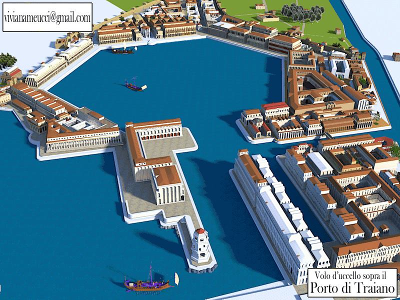
Less than fifty years later, Trajan (early 2nd century AD) had the port redesigned, excavating an internal hexagonal basin of about 32 hectares, connected with that of Claudius (however still in operation and used as an external harbor) through a large canal, and creating another canal to the south-east of the new port which made it possible to improve the system of connection with the Tiber. In the same years, Trajan also built the port of Centumcellae (Civitavecchia), 80 km north of Rome.
Over time, a gigantic logistic center grew up around the new port structures, the city of Portus, which became the main seaport of Rome, capable of fulfilling its function at least until the 6th-7th century. A.D.
With the construction of Portus both Pozzuoli and Ostia did not cease to function, but rather were strengthened: the first as an organized port center south of Rome in an area of ??great economic importance, the second as a port at the mouth of the Tiber and a great pole administrative and commercial, linked directly to the city through the Tiber and via Ostiense, and connected to Portus by a canal and via Flavia-Severiana. Ostia remained the administrative heart of the system until the beginning of the 4th century AD. when, with the Emperor Constantine, Portus became an autonomous municipality, an indication of its vital importance as a supply center for Rome.
The Port of Claudio
Designed and begun to build under Claudius and inaugurated by Nero in 64 AD, the imposing infrastructure was to ensure a basin where the loading and unloading of goods from large cargo ships arriving from all over the Mediterranean and their transshipment on boats can be carried out without danger. fluvial (naves caudicariae) suitable for the ascent of the Tiber to Rome.

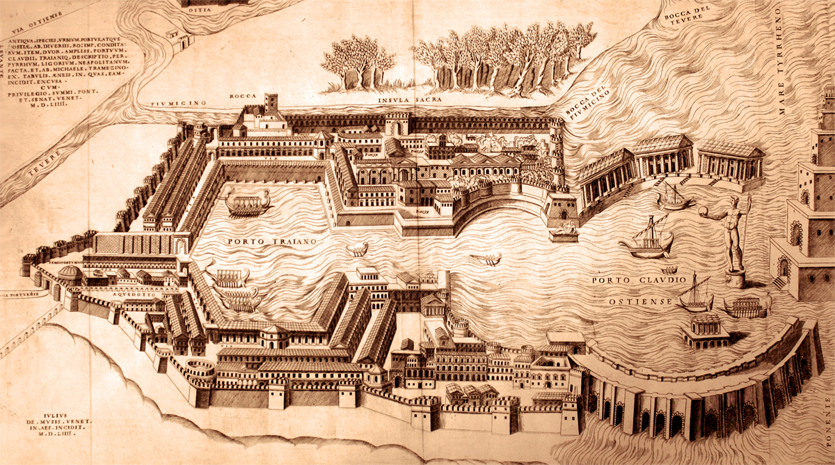
The port basin was partly dug into the mainland and partly protruding towards the sea and was bordered by two large piers converging towards the west entrance. Here, on an artificial island, stood a lighthouse in imitation of the famous lighthouse of Alexandria in Egypt, which signaled the entrance to the port. Another entrance was to be located to the north in the area near the airport, between the building of the current Ship Museum and the airport buildings. Claudio's project had foreseen the excavation of a series of artificial canals including the cd. Fossa Traiana (one of the fossae mentioned in an inscription of 46 AD) which ensured the connection between the sea, the port itself and the Tiber where goods destined for Rome were loaded on barges; belongs to the first century plant A.D. also the Darsena, a smaller internal basin intended for small coastal vessels, connected to the Fossa Traiana through another channel, the transverse communication channel.

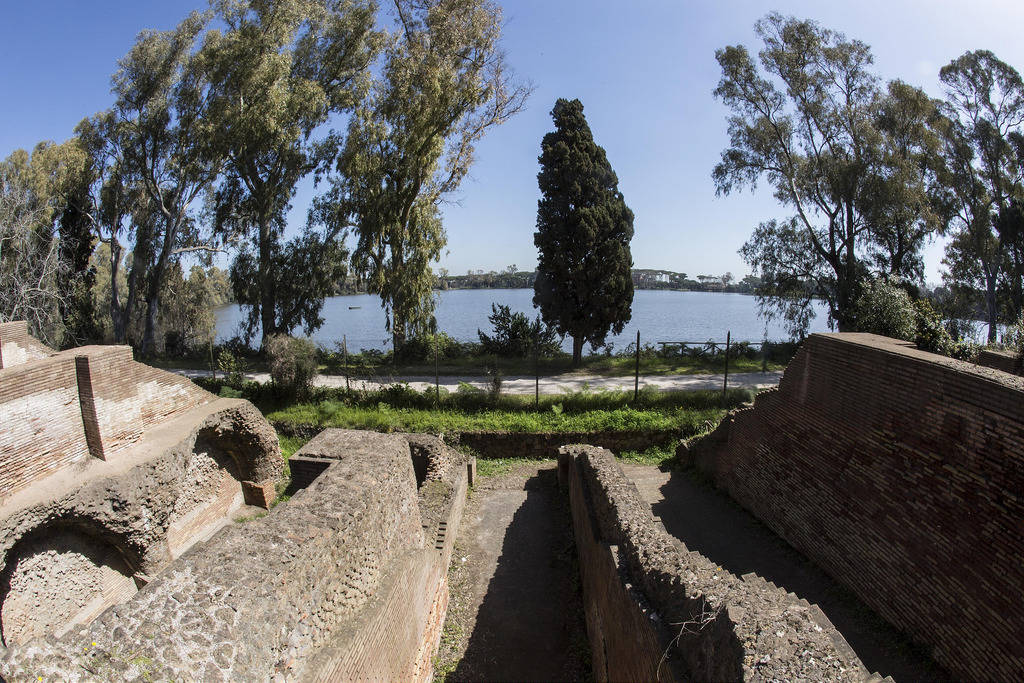
The foundations of one of the large piers (the right or northern one) are still visible today behind the Museum of Ships where they extend for an extension of about one kilometer to the west, while on the quay that delimited the port basin towards the land some service buildings of the port: the so-called Harbor office, a cistern and thermal buildings, built however in a later period (2nd century AD) after the plant of Claudius.
The Claudius basin, too large and extended towards the sea, proved unsafe because it was exposed to storms and with a tendency to cover up, for this reason, probably between 110 and 117 AD. the emperor Trajan had the entire port system renovated by expanding it.
The Claudius basin, too large and extended towards the sea, proved unsafe because it was exposed to storms and with a tendency to cover up, for this reason, probably between 110 and 117 AD. the emperor Trajan had the entire port system renovated by expanding it.
The Port of Trajan
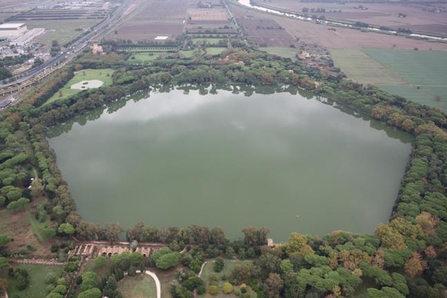
The fulcrum of the new port was represented by the basin (32 hectares) with its characteristic hexagonal shape, built by the emperor Trajan (probably between 110 and 117 AD), perhaps based on a project by the famous architect Apollodorus of Damascus; it is estimated that the hexagonal port could allow the simultaneous docking of approx. 200 large ships. The construction of the new basin and a new canal in the area between the hexagon and the Tiber did not involve the disposal of the large external port of Claudio which therefore continued to function as a roadstead. The hexagonal basin was connected to that of Claudius, through an internal channel. The system of internal channels created by Claudio continued to be used as well as the Darsena; the goods then continued to be loaded on boats that from the Fossa Traiana, the current Fiumicino canal, then reached the Tiber. Two roads, via Portuense and via Flavia-Severiana, flanked the waterways in the direction of Rome and Ostia.

A series of large service buildings were built around the hexagonal basin, mainly intended for storage and a temple. Warehouses were also built on the piers along the connecting canals and, but in an era subsequent to the Trajan age, also a spa complex. In an area between the Claudius and Trajan basins, at a central point of the system, the so-called Imperial Palace and other administrative buildings associated with it. In the same area, structures perhaps pertinent to arsenals, the probable shipyards, have recently been identified.
The warehouses, the horrea in Latin, are the main buildings in Portus. Together with the Testaccio department stores in Rome, behind the river port, they represent the largest logistics area of ??the ancient city.

The cd. Trajan's Department Stores, the successive Magazzini di Settimio Severo and the continuous expansion and restoration of these buildings make Portusuno one of the most important research centers to understand how storage structures in the Roman world were made and functioned, whose role was fundamental for the supply and nourishment of the population.
Ports of Claudius and Trajan in Fiumicino
Address: Via Portuense, 2329
Phone:
Site:
http://www.ostiaantica.beniculturali.it/it/aree-archeologiche-e-monumentali/porti-imperiali-di-claudio-e-traiano/Location inserted by
Marco Messina