Island of Pantelleria
Pantelleria is a volcanic island in the Strait of Sicily, closer to Tunisia (70 km) than to Sicily (100 km), and Italy’s southernmost island of significant size. Renowned for its distinctive dammusi stone dwellings, its DOC Passito di Pantelleria sweet wine produced from Zibibbo grapes, and a dramatic volcanic landscape of calderas and thermal springs, Pantelleria has been inscribed on the UNESCO World Heritage List for its ancient vine-training system known as alberello pantesco.
At a glance
- Type
- Volcanic island / UNESCO World Heritage cultural landscape
- Period
- Inhabited since the Neolithic; Phoenician, Roman, Arab, and Norman periods; UNESCO inscription 2014
- Style
- Vernacular dammuso architecture; volcanic Mediterranean landscape
- Location
- Strait of Sicily, Province of Trapani, Sicily, Italy
- Coordinates
- 36.8324° N, 11.9450° E
Overview
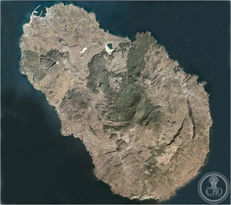
Pantelleria, covering 83 square kilometres, is the largest satellite island of Sicily and one of the most geologically active in the central Mediterranean, with an active volcanic system whose last eruption occurred in 1891. Its name derives from the Arabic “Bint el Rih” (Daughter of the Wind), a testament to its Mediterranean position at the crossroads of sea trade routes. The island’s population of around 7,500 survives primarily on wine production, fishing, tourism, and caper cultivation — Pantelleria capers are considered among the finest in the world.
History
Pantelleria was settled as early as the 4th millennium BC, and its obsidian deposits made it a major prehistoric trade hub across the central Mediterranean. Phoenicians established a colony called Cossyra, later controlled by Carthage, then Rome. Arab rule from 700 to 1072 AD profoundly shaped the island’s culture, language, and agriculture, including the introduction of the alberello vine-training system that UNESCO later recognized as outstanding universal value. Norman conquest under Roger I incorporated it into the Kingdom of Sicily, and it passed through Aragonese and Bourbon Spanish control before Italian unification.
What you see
The landscape is defined by Montagna Grande (836 m), the island’s central volcanic peak, surrounded by terraced vineyards, lava stone walls, and the distinctive dammusi: thick-walled cubic stone dwellings with domed roofs designed to collect rainwater in a cistern. The Specchio di Venere (Mirror of Venus), a thermal crater lake, lies at the centre of the island, while the coast alternates between basalt cliffs and sheltered natural pools such as the Balata dei Turchi. The Sese di Kuddia Attalora, a prehistoric funerary monument unique to Pantelleria, is among the most significant archaeological sites on the island.
Cultural significance
In 2014, the alberello pantesco vine-training system was inscribed on the UNESCO World Heritage List as a living cultural landscape representing over a millennium of human adaptation to a volcanic and arid environment. Pantelleria’s Passito wine, produced by sun-drying Zibibbo (Muscat of Alexandria) grapes, has been documented since at least the 17th century and remains one of Italy’s most distinctive dessert wines with DOC status since 1971.
Practical information
- Address
- Piazza Cavour 1, 91017 Pantelleria TP, Italy
- Hours
- Island accessible year-round; seasonal ferry and flight schedules vary
- Access
- Flights from Palermo and Trapani; ferry from Trapani (approx. 5–6 hours)
Getting there
Pantelleria Airport (PNL) receives seasonal flights from Palermo, Trapani, Milan, and Rome. Year-round ferry service operates from Trapani (overnight or day crossings). On the island, a rental car or scooter is essential as public transport is limited. The Strada Panoramica encircles the island in approximately 40 kilometres.
Sources & resources
Find it on the map
See this place and what’s around it →📷 Diventa un fotografo di Cultural Heritage Online
Condividi le tue foto dei luoghi: restano pubblicate con la tua firma come autore. Più vengono viste, più ti fai conoscere — e presto un concorso premierà le foto più apprezzate.
Accedi o registrati gratis per aggiungere una foto